Tropical Cyclones
Contents
What is a tropical cyclone?
Cyclone danger and impacts
Tropical cyclone severity categories
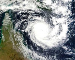
What is a Tropical Cyclone?
Tropical Cyclones are low pressure systems that form over warm tropical waters and have gale force winds (sustained winds of 63 km/h or greater and gusts in excess of 90 km/h) near the centre. Technically they are defined as a non-frontal low pressure system of synoptic scale developing over warm waters having organised convection and a maximum mean wind speed of 34 knots or greater extending more than half-way around near the centre and persisting for at least six hours.
The gale force winds can extend hundreds of kilometres from the cyclone centre. If the sustained winds around the centre reach 118 km/h (gusts in excess 165 km/h). then the system is called a severe tropical cyclone. These are referred to as hurricanes or typhoons in other countries.
The circular eye or centre of a tropical cyclone is an area characterised by light winds and often by clear skies. Eye diameters are typically 40 km but can range from under 10 km to over 100 km. The eye is surrounded by a dense ring of cloud about 16 km high known as the eye wall which marks the belt of strongest winds and heaviest rainfall.
Tropical cyclones derive their energy from the warm tropical oceans and do not form unless the sea-surface temperature is above 26.5°C, although once formed, they can persist over lower sea-surface temperatures. Tropical cyclones can persist for many days and may follow quite erratic paths. They usually dissipate over land or colder oceans.
Cyclone danger and impacts
Tropical Cyclones are dangerous because they produce destructive winds, heavy rainfall with flooding and damaging storm surges that can cause inundation of low-lying coastal areas.
Cyclones have wind gusts in excess of 90 km/h around their centres and, in the most severe cyclones, gusts can exceed 280 km/h. These very destructive winds can cause extensive property damage and turn airborne debris into potentially lethal missiles. It is important to remember that, during the passage of the cyclone centre or eye, there will be a temporary lull in the wind, but that this will soon be replaced by destructive winds from another direction.
Heavy rainfall associated with the passage of a tropical cyclone can produce extensive flooding. This can cause further damage and death by drowning. The heavy rain can persist as the cyclone moves inland and decays, hence flooding due to a decayed cyclone can occur a long way from the tropical coast as the remains of a cyclone move into central and southern parts of the continent.
The destructive winds accompanying tropical cyclones also produce phenomenal seas, which are dangerous both for vessels out at sea and those moored in harbours. These seas can also cause serious erosion of foreshores.
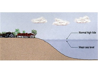
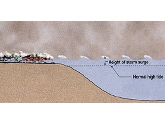
Storm surge and tides
Potentially, the most destructive phenomenon associated with tropical cyclones that make landfall is the storm surge. Storm surge is a raised dome of water about 60 to 80 km across and typically about 2 to 5 m higher than the normal tide level. If the surge occurs at the same time as a high tide then the area inundated can be quite extensive, particularly along low-lying coastlines.
What is Storm Surge
A storm surge is a rise above the normal water level along a shore resulting from strong onshore winds and / or reduced atmospheric pressure. Storm surges accompany a tropical cyclone as it comes ashore. They may also be formed by intense low-pressure systems in non-tropical areas.
Storm Surge + Normal Tide = Storm Tide
The combination of storm surge and normal (astronomical) tide is known as a 'storm tide'. The worst impacts occur when the storm surge arrives on top of a high tide. When this happens, the storm tide can reach areas that might otherwise have been safe. On top of this are pounding waves generated by the powerful winds.
The area of sea water flooding may extend along the coast for over 100 kilometres, with water pushing several kilometres inland if the land is low lying.
The combined effects of the storm tide and waves can knock down buildings, wash away roads and run ships aground. If you are caught in your home or in a car when a significant storm surge arrives, you may not survive.
The paths of cyclones are often erratic, which makes it hard to forecast exactly when and where a cyclone will cross the coast. This makes it difficult to predict how high the astronomical tide will be when the storm surge strikes, since the time difference between high and low tide is only a few hours.
As a result the Bureau of Meteorology, in its warnings to the public, makes the 'worst case' assumption that the cyclone will cross the coast at high tide.
Had Cyclone Tracy arrived in Darwin during a high tide, the devastation would have been even worse. Similarly, a low tide saved Townsville from a dangerous storm surge that accompanied Cyclone Althea in 1971.